News
MultiDEFusion: an open-source library dedicated for the integration of geodetic observations
07-05-2024
MultiDEFusion is an open-source library that enables the Fusion of Multi geodetic techniques ensuring long-term observations of ground DEFormation. The software, developed in a Python environment, enables the integration of permanent GNSS observations together with InSAR radar data.

The MultiDEFusion library expands the existing approach of integrating geodetic observations introduced in the article Tondaś et al., 2023, by allowing the simultaneous application of three InSAR computational methods: DInSAR, SBAS, and PSI. Furthermore, radar observations can be derived from three independent orbits with the possibility of implementing 9 elements (pixels or PS points) for each computational method. Detailed software documentation, including references to the trial data set, is available at https://damiantondas.github.io/multidefusion.
 more...
The MultiDEFusion library expands the existing approach of integrating geodetic observations introduced in the article Tondaś et al., 2023, by allowing the simultaneous application of three InSAR computational methods: DInSAR, SBAS, and PSI. Furthermore, radar observations can be derived from three independent orbits with the possibility of implementing 9 elements (pixels or PS points) for each computational method. Detailed software documentation, including references to the trial data set, is available at https://damiantondas.github.io/multidefusion.
more...IGiG scientific seminar - Prof. Uwe Soergel
06-05-2024
 IGiG is pleased to invite you to a scientific seminar to be held in the IGIG library (100G) on May 9, 2024 from 9:00-10:00 a.m. The presentation, entitled "Trends in Remote Sensing: Constellations, Crowd Sourcing and Services" will be given by Prof. Uwe Soergel from University of Stuttgart.
 Please refer to BIO to find out more about our speaker.
We look forward to seeing you all on Thursday.
more...What have we learned about BeiDou from new laser observations?
29-04-2024
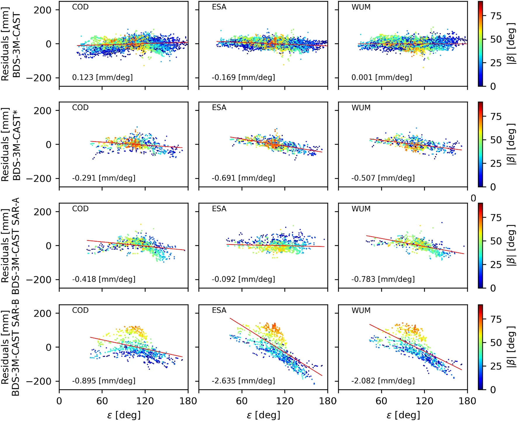
Recent enhancements in global satellite navigation have taken a significant leap forward thanks to the International Laser Ranging Service (ILRS), which now tracks an additional 20 BeiDou-3 satellites orbiting the Earth. This expansion from the initial four satellites under surveillance marks a major milestone for the BeiDou Satellite Navigation System (BDS), a critical component of the global navigation structure alongside GPS and Galileo.
Our team at the Associated ILRS Analysis Center has detailed these advancements in a new study, "Satellite Laser Ranging to BeiDou-3 Satellites: Initial Performance and Contribution to Orbit Model Improvement" by Zajdel et al., 2024. You can read more about the study here: GPS Solutions, Volume 28, 100 (2024). LINK
more...
Our team at the Associated ILRS Analysis Center has detailed these advancements in a new study, "Satellite Laser Ranging to BeiDou-3 Satellites: Initial Performance and Contribution to Orbit Model Improvement" by Zajdel et al., 2024. You can read more about the study here: GPS Solutions, Volume 28, 100 (2024). LINK
more...IGiG Summer Internships 2024
16-04-2024

The Institute of Geodesy and Geoinformatics presents a proposal of paid summer internships for students for 2024. The internships duration is up to three months. The titles and topics of the internships are in the appendix. The deadline for submitting applications is May 10, 2024. Please contact the tutors of individual internships directly (e-mail).
more...IGiG scientific seminar - Prof. Wolfgang Huhnt
08-04-2024
 IGiG is pleased to invite you to a scientific seminar to be held in the IGIG library (100G) on April 11, 2024 from 9:00-10:00 a.m. The presentation, entitled "Space partitioning as the basis for geometric modeling in architecture, engineering and construction" will be given by Prof. Dr.-Ing. Wolfgang Huhnt from TU Berlin.
 We look forward to seeing you all on Thursday.
more...Archive: | 1 | 2 | 3 | 4 | 5 | 6 | 7 | 8 | 9 | 10 | 11 | 12 | 13 | 14 | 15 | 16 | 17 | 18 | 19 | 20 | 21 | 22 | 23 | 24 | 25 | NEXT PAGE »
 |
 |
 |
 |
Contact
|
INSTITUTE OF GEODESY AND GEOINFORMATICS
Wroclaw University of Environmental and Life Sciences Grunwaldzka 53 50-357 Wroclaw NIP: 896-000-53-54, REGON: 00000 18 67 Phone +48 71 3205617 Fax +48 71 3205617 e-mail: igig@upwr.edu.pl |